| FRENCH FOLLY OR OUR FUTURE | ||
|
David and I had planned to go to Germany to see the Segelflugmesse event and then on to the Vosges Mountains in France in July 2020 for some slope flying, sadly it was not to be. Chinese bio-security had apparently failed at a government/military research lab in Wuhan province in 2019 and, as we all know to our cost, sabotaged the economies and lives of billions in countries across the globe. I’m personally not sure this is the real reason for the pandemic but then I am a big cynical conspiracy theorist. Putting aside my own ideas of genetic, DNA, ethno-bomb research we had prepared well for our sojourn to Schengen Europe; the Channel ferry and Gasthaus/Camping stops had been booked and I still have the €500 I exchanged for the trip. We passed our French Drone Flying test (Training Certificate) and registered models and created registration labels (which must be able to read from 30cm) for the models but the virulent Chinese ‘Plague’ scuppered our jolly. The German glider meeting was cancelled again this year so we shall not be going to the Continent in 2021. |
 |
|
|
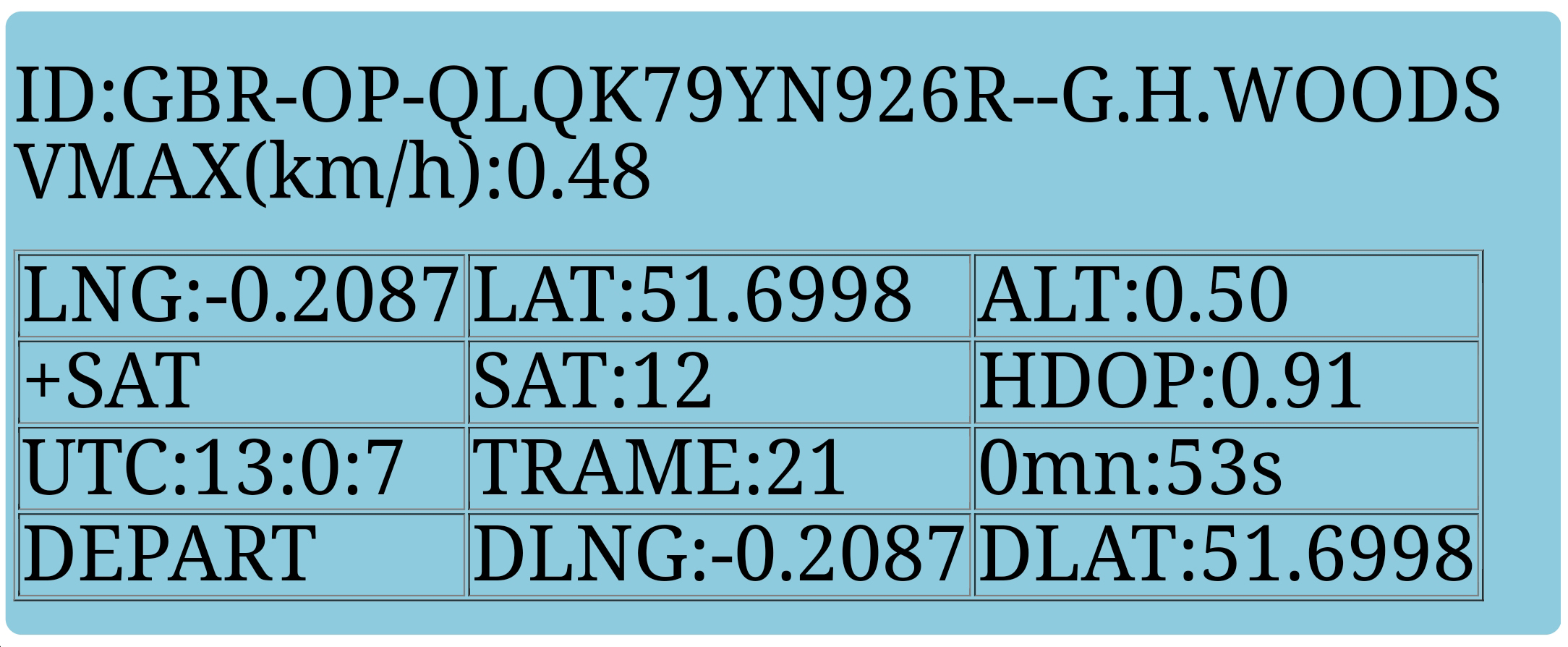
In France, one would apply to the AlphaTango website for a model registration number which is inserted in the Sketch (Firmware) enabling anyone, especially a Gendarme, logging into WiFi to identify the flier. The data shown here is a Screenshot from my Smartphone. I inserted by own CAA I.D. number as I haven’t registered a model for France. While this particular unit had not been tested airborne at the time of writing I can say that the range came out at 110m ground to ground. In operation the can operate up to 7.4v as it has a 3.3v voltage regulator. The Smartphone WiFi app is connected to the Balise on the network page and the address http://192.168.1.*/ put in the phone’s web browser – and the phone reveals the blue screen you see above. (*any unused number from 1 to 256) In 2021, France introduced a new rule for modellers flying models over 800g, something with which we may well have to deal in future. Height limits in France had already been set at modest heights of 30m, 50m and 100m in various parts of controlled airspace, especially around airfields, and up to 150m elsewhere. The areas are annotated on a Web Portal and Map for RC fliers if you’re interested. |
 |
|
 |
This year, however, that new rule, delayed by 6 months, came into being stating that models weighing over 800g, not flown on registered flying sites, generally speaking fixed power clubs I suppose, would have to carry a transponder or beacon of sorts. Where this leaves slope soaring over there; I’m not sure every sea cliff and hill in France could be registered as a flying site with the DGAC (CAA equivalent). The new rule says that every ‘drone’ should carry a Balise Électronique (Beacon) or as we would say, a transponder that transmits the GPS coordinates of the model at take-off, the altitude and speed of the model and its GPS position in the sky. |
|
|
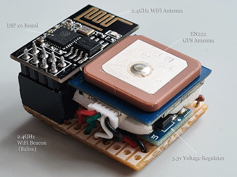
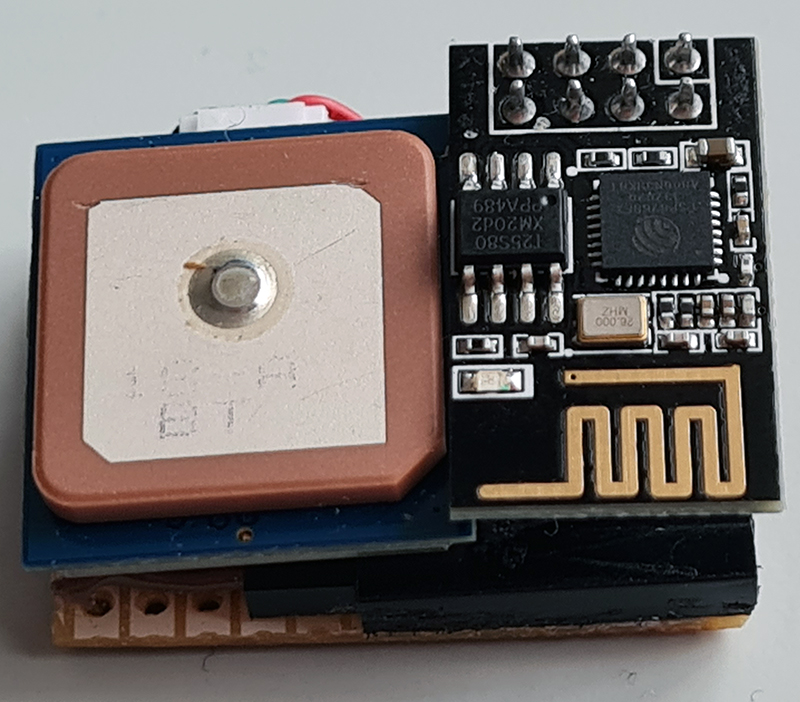
Some expensive quadcopters (DJI) already have ‘sense and avoid’ systems built into their software and of course carry GPS for RTH (return to home) and Waypoint inputs but I never heard of it for model aircraft. One manufacturer (TBS Crossfire) has even prepared such a thing one of their receivers for the FLARM system. Here’s some new jargon for you now we’re getting into transponders: conspicuity, ADS-B, FLARM, sense and avoid, situational and traffic awareness, collision avoidance. However, FLARM and ADS-B transponders, their associated equipment and software meant for General Aviation are expensive so I guess the French initiative using 2.4GHz GPS module made from a couple of ready made PCB boards (an ESP-01 + 3.3v regulator) for the airborne unit and a Smartphone as a receiver on WiFi Channel 6 for a few Euros is a more accessible system if modellers have to have one. (from FlashRC/ FFAM) A homemade version is even cheaper costing around €25 with bits from eBay, Banggood or AliExpress. Luckily, a design was published on Pierre Rondel’s Planet-Soaring French website so David went ahead and built one for me using piece of stripboard and a 3D printed case. |
The parameters are explained … VMAX: Highest Speed LNG: Longitude in Flight LAT: Latitude in Flight ALT: Height above ground (zeroed on switch on) SAT: No of satellites (GPS, Galileo, Glonass) HDOP: Horizontal Dilution Of Precision a measure of positional accuracy, the more satellites the better UTC: Time, GMT in this case TRAME: number transmissions (3 sec intervals) DLONG and DLAT: the departure point position |
|
 |
This small unit fits inside a 3D printed case just 37 x 27.5 x 20 mm and could be accommodated in many models. The PCB zigzag aerial can be replaced with a whisker type 2.4 antenna or a dipole by judiciously cutting the copper track and some careful soldering for increased range. A slightly larger available board, ESP 32, enables the GPS data to be channelled to a FrSky telemetry receiver but that’s for electronic buffs. Most of the components for this device are available from eBay or Banggood. |
I’ve no idea if transponders or beacons will ever be mandatory in the UK; I suspect they may come but only for heavier or larger models perhaps over 25kg, maybe 1/3 scale gliders, large vectored thrust jets or IMAC planes. I heard a rumour that such models would have to carry a ‘proper’ ADS-B type transponder. Anecdotally, I should say that these models are already flown well above the regular 120m height limit illegally so should really carry one. |
|
While the FLARM and ADS-B transponder systems using powerful airborne transmitters are really for conspicuity to other sky users, for collision avoidance and situational awareness, the French system described here is solely to identify a naughty remote model flier’s altitude from a distance of up to, say, 500 to 1000m, but for what purpose? I shall, however, be ready for France when we are finally allowed to travel, but what will happen here? Who Knows? ..-. / .- / ...- / --- / -. / .. / ..- / ... / .-.-.- / -.-. / --- / -- |
||