RICHBOROUGH
(Portus Rutupiae - The Muddy Estuary)


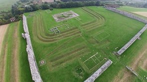
Click NO FRAMES above then click image for aerial video

or go to www.vimeo.com/75574628


1

Aerial photograph from south side - fort area & amphitheatre2

Fort and Amphitheatre from north side - notice crop marks3

4

Overlay5

Looking along west wall - outside6

West wall - outside7

Rutupiae fort plan after Detsicas8

South wall - outside9

South wall - thickness10

Quadrifons - Archway model as imagined from base remaining11

West wall - inside12

Click any thumbnail for a LARGER image

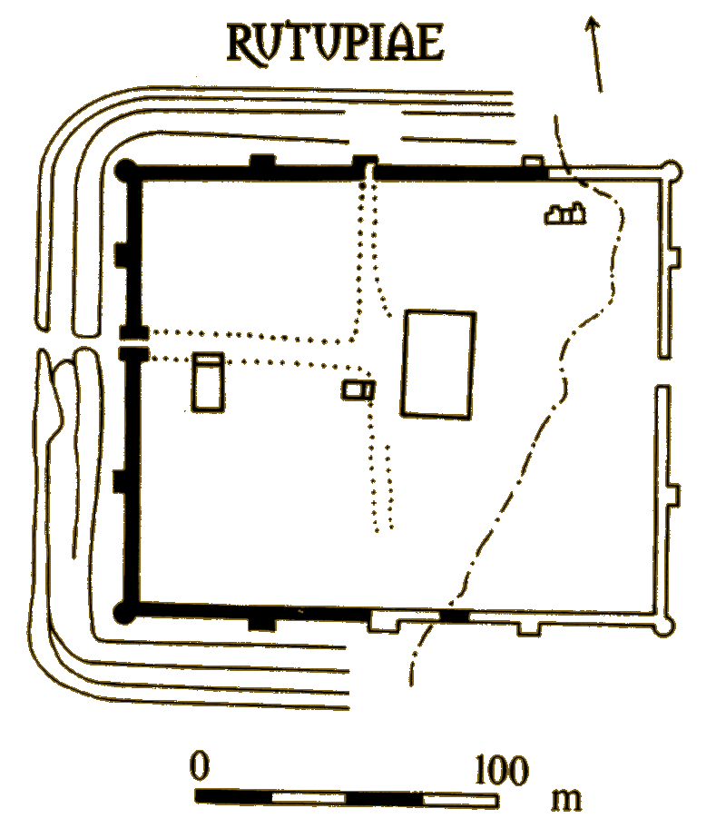
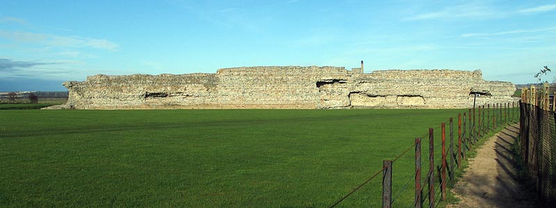
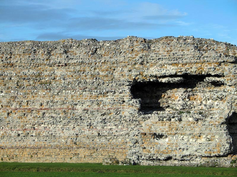
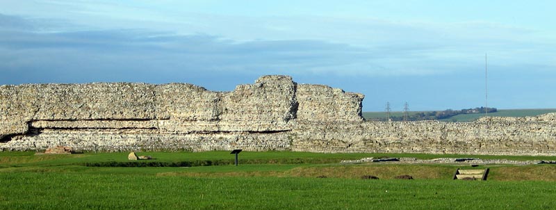
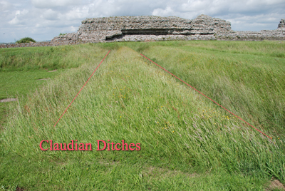
The Saxon Shore Fort

The walls at Richborough are massive, what one sees on approaching the site are the remnants of the Saxon Shore Fort North Wall detailbuilt around AD 275 on the edge of the bluff by the Wantsum River which runs to the sea at Sandwich and north to Reculver. When I visited the site in October 2004 the site was closed so my images are from outside the perimeter fence. The Saxon Shore fort is truly monumental, still standing at least 7m. high, and it replaces an earlier fort of wood with an earth rampart from AD 250 defending against raids from pirates, or more likely, an invasion force from N. Europe. It encloses an area of some 50 acres I reckon. Looking along the west wall in image 6 one can see that the wall is faced with dressed limestone cubes but in-filled with rubble, it's very impressive. On the corner there is a circular bastion the base of which is still visible (just) in my image. The wooden footbridge is where the road (Via Praetoria/Watling Street) to Canterbury would have been. In image 7 you can see the length of the wall and characteristic Roman lacing courses of bonding tiles, likewise the south wall, image 9. Image 10 attempts to show the thickness of the wall. Surrounding the fort are two massive ditches on three sides which any invader would have had to cross before getting near the wall, see aerial images 2 & 3. The fourth side is bounded by the cliff and water below.

The Aerial Images

OverlayImage 5 is a composite in which I have overlaid a plan of the area (after Detsicas) over the aerial image. The images (5 & 8) reveal the two outer ditches I just mentioned and also the triple ditch from the earth and wood fort of AD250 (also the base of the arch and mansio). This triple ditch encloses a much smaller area than the later Saxon fort. Look carefully here at the image and one can see a third set of ditches - just one section of unfilled ditches from Claudian times - I marked it CD. This was the double ditch which formed the original Roman bridgehead in AD43. It ran more or less parallel with the line ofCludian ditches the bluff perhaps as long as 1km, I imagine. Aulus Plautius landed his 40,000 men here in AD 43 and dug the ditch for protection; in the event there was no opposed landing since the Cantiaci were friendly to the Romans and by AD45 it appears the ditches were mostly filled in.


The Structures

Quadrifons - Archway model as imagined from base remainingThe fort became a supply base with the Via Praetoria and a road running between the north and south gates dividing the fort area, the resulting insulae were filled with many storerooms and granaries, a mansio and maybe an administration building - Richborough after the invasion remained a supply depot for the army and a small  vicus seems to have built up around it. Look for the green crop marks of the village in aerial image 3.  A staggering 56,000 coins have been found on the site!

Later on, army use of the site diminished as the army moved out and presumably food need no longer be imported. By AD 85, however, Richborough was the main entry port into Britain. A monumental arch was built under Domitian for the gateway into Britannia. It was a huge arch (quadrifrons), the base still survives as the 'cross' in the aerial images. Made of flint and mortar the base supported an arch estimated at 25m. high and faced with gleaming white Carrara and pink Pentelic marble and with a bronze horse statue on top that will have been seen by boats from far away on a good 
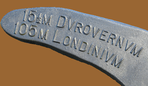
day. For a time Portus Rutupiae was the entrance to Britannia and the beginning of Watling Street, the road which runs all the way to Chester. 
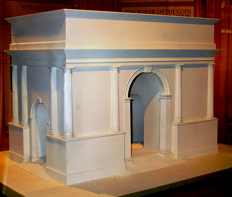
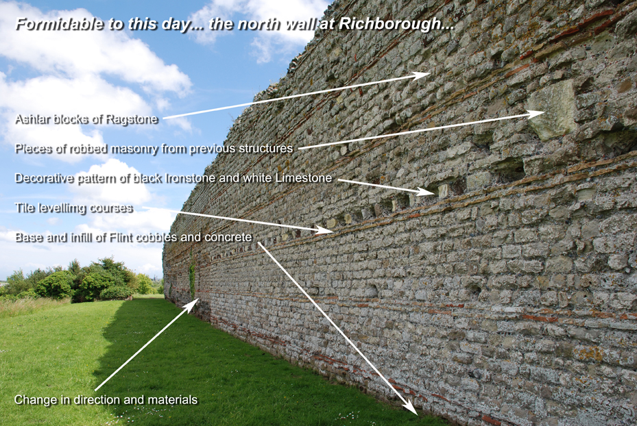
Just a few fragments of the arch remain apart from the base, image 11 is a model reconstruction of it housed in the museum. If you look carefully image 12 just shows the base as does the better annotated one below. The beginning of second century must have seen Richborough in its heyday but by Antonine times (mid-2nd century) the entry port emphasis had switched from Richborough to Dover. By 250 the arch was gone, the mansio was still there and there was a classic Roman bathhouse too.


The Amphitheatre (Ludus)

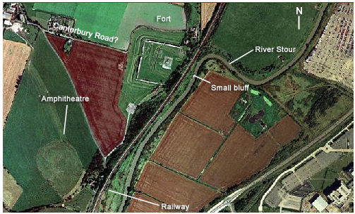
The aerial photograph 3 also shows an amphitheatre of about 50m. in diameter. I tried to access it and got to the boundary fence but there is nothing much to be seen from ground level. Quite what it was for I do not know but presumably games of some sort for the soldiers or a place for exercising and training. The garrison at Richborough was a vexillation of Legio II Augusta, probably no more than 500 men. By the time of the Saxon Shore fort the Quadrifrons had been demolished.

Recent geophysical work done on the site hinted not only at a huge vicus around the fort and perhaps docks and wharves as well but something monumental on the site of the amphitheatre. Two large masses of masonry either side of the entrances to the ludus indicate there may have been two large towers or arched entranceways as well as its other two entrances to the theatre making four in all. If this is the case then the theatre can hardly have been merely for training soldiers and may have had an alternate use.

[A field walking course around Richborough fort is available from UKC in the year 2005/6.]


No Roman coursework?

In the summer, the Richborough site, operated by English Heritage, is sometimes used for Roman displays and demonstrations. These images are from that time.

gladius &  mail

arrows - blade & bodkin tips

Quern/millstone

shields

Click thumbnails for a LARGER image